GPX & TPO route and waypoints attached. GPX is not an allowed extension here, thats not nice. You will have to rename from XLS to GPX.
edit: GPX is now allowed, I have changed the extension to GPX, thanks John.
I have revised the start, Bob D. informed me there is a trail of sorts that follows the unnamed creek on the east side.
Peak Dash route details
10 posts
• Page 1 of 1
Peak Dash route details
![]() by DSunwall » Sun Sep 21, 2008 2:26 pm
by DSunwall » Sun Sep 21, 2008 2:26 pm
- Attachments
-
 LOJ LCW Peak dash route (2).tpo
- Revised Topo route
- (6.83 KiB) Downloaded 262 times
-
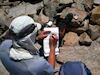
- Route beginning
-
- Full route
-
- LOJ LCW Peak dash route (2).gpx
- revised GPX route
- (11.12 KiB) Downloaded 268 times
Last edited by DSunwall on Wed Sep 24, 2008 11:01 am, edited 9 times in total.
-
DSunwall - Posts: 390
- Joined: Sat Mar 26, 2005 5:58 pm
- Location: Castle Rock, Co
![]() by DSunwall » Sun Sep 21, 2008 8:43 pm
by DSunwall » Sun Sep 21, 2008 8:43 pm
The route begins on the Colorado trail heading east from Long Gulch. We will stay close to the unnamed creek on the east side all the way up. It is one and a quarter miles and 1700' of elevation gain to the X Y saddle. This is the toughest grind of the trip, except the return at the end of the day might feel worse.
From the saddle it is a little over 500' of gain to the summit of Y. The drops between most of the peaks are less than 500', one exception being Zephyr too No Payne where we drop 1000' to Craig Creek.
We can fill on water here, I checked Craig creek out Saturday, there is a lot of good clean water flowing. I'll probably start with less than 2 liters and fill 2 more liters at the creek crossing. This will be only 6 miles into the hike but will allow a light start. Fluoride tabs are fast and light, I generally take separate containers so I don't have to purify in the bladder. Gateraide or some thing to mix might be good but the water doesn't taste bad.
Payne Benchmark to Platte Peak might be the slowest 5 miles on a ridge that does have trees and maybe some talus if I remember right. I am fairly sure we can miss most to the talus.
Anyone shortcutting back without a GPS I would encourage to bail soon enough to return with some daylight. The unnamed creek can be used as a handrail on the way down, keep the creek to the right.
If you leave from the eastern half of the hike the direction back will be generally SW, and more straight south from the west half. If you end up on the road lower than 9800' head east, the camp is at roughly 9900' and the Trail head 10100'.
From Platte Peak its a long open country hike through grass with very few rocks or bushes. Peak X is the last Peak. From X head back to the X Y saddle and try find the trail through the bushes and then into the trees. The unnamed creek is somewhat of a hand, keep the creek on your right.
Last edited by DSunwall on Thu Sep 25, 2008 7:16 pm, edited 2 times in total.
-
DSunwall - Posts: 390
- Joined: Sat Mar 26, 2005 5:58 pm
- Location: Castle Rock, Co
![]() by DSunwall » Sun Sep 21, 2008 8:58 pm
by DSunwall » Sun Sep 21, 2008 8:58 pm
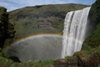
A few photos of the start and Craigs creek.
- Attachments
-
- The first Peak, Peak Y.
-
- Craigs creek
-
- Looking back south from X Y saddle, small cairn circled. Trail through the bushes.
-
- Typical bushwhack on the ascent.
-
- Colorado trail
Last edited by DSunwall on Wed Sep 24, 2008 10:37 am, edited 1 time in total.
-
DSunwall - Posts: 390
- Joined: Sat Mar 26, 2005 5:58 pm
- Location: Castle Rock, Co
![]() by Jeremy Hakes » Mon Sep 22, 2008 8:38 am
by Jeremy Hakes » Mon Sep 22, 2008 8:38 am
Good work, Dwight. Thanks for the research. Sounds like I'm going to be a little burdened with all those extra registers and canisters. I'll barely have room for water! 
-
Jeremy Hakes - Posts: 503
- Joined: Mon Aug 21, 2006 12:39 pm
- Location: Golden, Colorado
Re: Peak Dash route details
![]() by John Kirk » Mon Sep 22, 2008 8:59 am
by John Kirk » Mon Sep 22, 2008 8:59 am
DSunwall wrote:GPX is not an allowed extension here, thats not nice.
Gee Dwight,
All ya gotta do is ask (gpx is allowed now).
-

John Kirk - LoJ Architect
- Posts: 1607
- Joined: Sun Jan 02, 2005 1:04 am
- Location: Lakewood, CO
![]() by Jeremy Hakes » Wed Sep 24, 2008 10:44 am
by Jeremy Hakes » Wed Sep 24, 2008 10:44 am
Can you please update it on my GPS now, too? All this extra work ...
-
Jeremy Hakes - Posts: 503
- Joined: Mon Aug 21, 2006 12:39 pm
- Location: Golden, Colorado
![]() by Jeremy Hakes » Wed Sep 24, 2008 10:47 am
by Jeremy Hakes » Wed Sep 24, 2008 10:47 am
Dwight - I can only assume you are bringing a chainsaw to clear all that deadfall debris to ensure the safety of the group? 
-
Jeremy Hakes - Posts: 503
- Joined: Mon Aug 21, 2006 12:39 pm
- Location: Golden, Colorado

![]() by Jeremy Hakes » Wed Sep 24, 2008 10:55 am
by Jeremy Hakes » Wed Sep 24, 2008 10:55 am
DSunwall wrote:Jeremy Hakes wrote:Can you please update it on my GPS now, too? All this extra work ...
ahhhh, whining already.
Ah, funny! :) I was hoping you'd knock that one out of the park. :)
-
Jeremy Hakes - Posts: 503
- Joined: Mon Aug 21, 2006 12:39 pm
- Location: Golden, Colorado
10 posts
• Page 1 of 1
Return to Summit Hikes and Climbs
Who is online
Users browsing this forum: No registered users and 1 guest