Does anyone recognize these peaks, part two...
11 posts
• Page 1 of 1
Does anyone recognize these peaks, part two...
![]() by KirkB » Wed Apr 03, 2013 10:34 am
by KirkB » Wed Apr 03, 2013 10:34 am
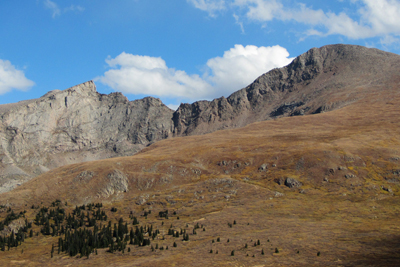
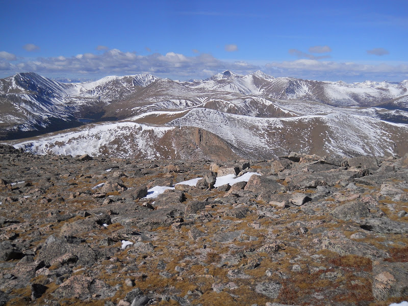
My late friend Sean's legacy lives on. As I mentioned in my last post (March 13th), Sean took a series of photographs & videos in or near each of the following Front Range Wildernesses during his trip to Colorado last Aug-Sept: Rawah, Indian Peaks, Mount Evans and Lost Creek (in chronological order). Over the course of the last month, I've been successful in identifying where over 1,100 stills and nearly 280 videos were taken, in part with the invaluable help of members from this forum. In addition to the above images an equal or lesser number of "scenic fragments" exist as well (pix with no uniquely identifiable features or reference points such as aspens & willows in fall colors, late season wildflowers, various wildlife, small scale landforms, etc.) which clearly will be impossible to pinpoint to a single location but which eventually can be placed within general geographic settings by the date & time they were taken. Beyond these, I am down to three videos and a couple of stills which are distinct enough to be identified but have thus far resisted all attempts on my part to do so (either I'm approaching burnout or I've just never seen them from the particular viewpoints provided). I'm hoping the members of this forum will indulge me one last time in order to help me identify these remaining few "orphans." Towards this end, I hope to make two posts, the current one with two frames from each of two videos and a later one with three frames from one video and a single related still. While the first of these sets could have been taken with a telephoto lens, the rest were definitely taken from some kind of aerial platform (the base of reference changes during the sequence: Sean was a licensed pilot but he also had the means to hire either a small plane or helicopter should he choose). Again, I thank you for your help in advance (note the hikers on the road/trail in the first photo of the 2nd set: I thought it could be either Arapaho or Rollins Pass but just can't seem to get either to fit).
- Attachments
-
- Notched Peak (wide view)
-
- Notched Peak (close up)
-
- Snowy Summit (wide view)
-
- Snowy Summit (close up)
- KirkB
- Posts: 9
- Joined: Wed Mar 13, 2013 6:59 am
Re: Does anyone recognize these peaks, part two...
![]() by John Kirk » Wed Apr 03, 2013 12:38 pm
by John Kirk » Wed Apr 03, 2013 12:38 pm
-

John Kirk - LoJ Architect
- Posts: 1606
- Joined: Sun Jan 02, 2005 1:04 am
- Location: Lakewood, CO
Re: Does anyone recognize these peaks, part two...
![]() by ChrisRoberts » Wed Apr 03, 2013 9:04 pm
by ChrisRoberts » Wed Apr 03, 2013 9:04 pm
The top two are of the backside of Paiute Peak

- ChrisRoberts
- Posts: 23
- Joined: Sun Aug 28, 2011 6:44 pm
Re: Does anyone recognize these peaks, part two...
![]() by KirkB » Thu Apr 04, 2013 6:02 am
by KirkB » Thu Apr 04, 2013 6:02 am
Thanks to you both for seeing what I cannot: I should have recognized these peaks but, as I intimated, after a month of sunup to sundown effort I'm obviously way past fried.
I'll follow with the second and last set of photos in the hopes that someone can recognize them as well...
The first three are frames from a video sequence while the fourth was an isolated still that I just happened to notice later was a close-up of the background appearing in the first three (although from a viewpoint further down the same valley). What appears to be a "Pike's Peak-like" massif is barely visible on the skyline in the right-hand third of this close-up just behind the most distant range and directly under that last fluffy white cloud (as distinct from the gray clouds trailing off to its right).
- Attachments
-
- Ridge-Valley (backside)
-
- Ridge-Valley (summit view)
-
- Ridge-Valley (overview)
-
- Ridge-Valley (close-up)
- KirkB
- Posts: 9
- Joined: Wed Mar 13, 2013 6:59 am
Re: Does anyone recognize these peaks, part two...
![]() by KirkB » Sun Apr 07, 2013 8:36 am
by KirkB » Sun Apr 07, 2013 8:36 am
I'm definitely tired. When I posted the above I meant to explain how this project had suddenly grown from only 80 or so photographs to over 2,000. Within a couple of days after my first post, a registered package from Sean's wife arrived at my door containing 7 memory sticks (from 1 to 8 gb) plus a frantic note (this treasure trove had been discovered in one of his camera bags). She hoped I could separate out any photos taken up in the Canadian Rockies for a documentary he was doing with a Canadian television network which they needed before the end of April. Fortunately, I was able to get these pulled over the next five days by quickly putting everything in chronological order and then carefully going over the last couple hundred shots leading up to the timeframe of his Colorado trip (the Canadian images I then returned via registered mail). What I also uncovered at the same time, of course, were 2 and a half sticks with additional photos & videos from the latter (she later sent me three more sticks from another bag but these were from the Pacific Crest Trail trip he'd done earlier that spring): it was this unexpected bounty which has kept me hunched over a computer screen for the last three weeks.
I'll leave you with a series of Google Earth images which demonstrate not only what an incredible resource it is, on the one hand, but also why sometimes it leaves so much to be desired, on the other: the Sawtooth-Mt. Bierstadt images were spot-on but it's easy to see why I had so such trouble identifying the Paiute Peak shots (compare with the original shots, above).
I'll leave you with a series of Google Earth images which demonstrate not only what an incredible resource it is, on the one hand, but also why sometimes it leaves so much to be desired, on the other: the Sawtooth-Mt. Bierstadt images were spot-on but it's easy to see why I had so such trouble identifying the Paiute Peak shots (compare with the original shots, above).
- Attachments
-
- Paiute Peak (east view)
-
- Paiute Peak (west view)
-
- Mt. Bierstadt-Sawtooth (trail view)
-
- Mt. Bierstadt (side view)
- KirkB
- Posts: 9
- Joined: Wed Mar 13, 2013 6:59 am
Please have another look at the photos in set two...
![]() by KirkB » Tue Apr 16, 2013 8:41 pm
by KirkB » Tue Apr 16, 2013 8:41 pm
Today would have been my friend Sean's 69th birthday. It had been my goal to have all his photographs & videos identified by this date so as to present them to his wife as a lasting tribute to his memory. Partially with the invaluable help of the members of this forum, I was able identify, as to time & place, where the bulk of his images (over 2,000) were taken, and these I sent her yesterday via overnight mail.
Four remain (along with several others obviously taken in the same relative area). These four I appended as a second set on April 4th, following John & Chris' identification of the first, but, unfortunately, have not as yet received any replies. Looking back at it now, I’m wondering whether, by inserting them “midstream” in this fashion, they might have gotten lost in all the confusion.
Perhaps because they are the last to be identified, these four have somehow become key to and symbolic of this whole project. For this reason I hope that visitors to this forum might be stimulated to take one last look and possibly remember having seen at some time in the past, and therefore recognize now, the scenes depicted therein.
As for the last image, other than the range in the foreground covered with tundra (clearly between 12-13,000 feet), all those in the background, running roughly parallel to the former, appear to be below timberline. And while it looks for all the world like this landscape ought to be somewhere along the Front Range, I've scanned both sides of the Continental Divide from the Wyoming border to Mt. Harvard via Google Earth to no avail.
Where in Colorado could these have been taken?
Thank you for taking a second look...
- KirkB
- Posts: 9
- Joined: Wed Mar 13, 2013 6:59 am
Re: Does anyone recognize these peaks, part two...
![]() by lukePlumley » Tue Apr 16, 2013 10:40 pm
by lukePlumley » Tue Apr 16, 2013 10:40 pm
Hi Kirk,
I am still working on getting the right angle for your 4 photos. First thought was that the range in the background looked like the Williams Fork Mountains from the northeast somewhere (Byers/Bills Peak areas). That doesn't work though with your lake in the photo. Second thought was looking from somewhere up in the Rawah range southeast over the Laramie River valley and down towards the Comanche Peak/Mummy Range with Longs as your large peak on the right. This looks better to me, but the angles don't work. I will keep at it.
lp
- lukePlumley
- Posts: 199
- Joined: Fri Nov 10, 2006 4:16 pm
- Location: Silt, CO
Re: Does anyone recognize these peaks, part two...
![]() by KirkB » Wed Apr 17, 2013 5:15 am
by KirkB » Wed Apr 17, 2013 5:15 am
Thanks, Luke, and to anyone else who may be working on this: I truly appreciate it!
- KirkB
- Posts: 9
- Joined: Wed Mar 13, 2013 6:59 am
Re: Does anyone recognize these peaks, part two...
![]() by John Kirk » Wed Apr 17, 2013 9:52 am
by John Kirk » Wed Apr 17, 2013 9:52 am
I've identified the exact spot and angle...
It's looking north toward Hells Hole from the saddle between Gray Wolf and unranked 12988 to its west, where the aspen-covered peak in the foreground is Griffith.
http://listsofjohn.com/PeakStats/QMap.php?lat=39.6115&lon=-105.6754&z=14&t=m&P=300
The peaks in the far background are Flora, Parry, Eva, James, etc.
This photo confirms it from a Gray Wolf Trip report (see shape of face under the ridge in dead center of photo):
-
John Kirk - LoJ Architect
- Posts: 1606
- Joined: Sun Jan 02, 2005 1:04 am
- Location: Lakewood, CO
Re: Does anyone recognize these peaks, part two...
![]() by mikeofferman » Wed Apr 17, 2013 11:50 am
by mikeofferman » Wed Apr 17, 2013 11:50 am
Good job John! Here is a crop of a photo I took on the Sawtooth looking North.
- Attachments
-
- mikeofferman
- Posts: 141
- Joined: Tue Nov 21, 2006 8:47 pm
- Location: Windsor
Re: Does anyone recognize these peaks, part two...
![]() by KirkB » Fri Apr 26, 2013 9:01 am
by KirkB » Fri Apr 26, 2013 9:01 am
After making my last post, I apparently forgot to check the box requesting to be notified when someone replied. Not hearing anything, I was content instead to use the time to get caught up on other tasks abandoned during the two months just past. Some nagging thought, however, made me sign on late yesterday. And to my great amaze there were two new postings and a proposed solution!
At first I was skeptical, thinking that these unrecognizable images had perhaps been posted to the wrong topic. After firing up National Geographic TOPO!, however, and looking for the peaks & valleys mentioned...seeing the ridgeline & the small lake in just the right spot, the upper hillsides curving ever so slightly to the left, the long straight valley below with its curious trail/4WD road along one rim, the vague hint of a lake far below (just like the "close-up" image I'd posted so long before)...then it was I knew, without a shred of doubt, that the last major landscape had at long last been identified...that Sean's & now my quest had both been fulfilled (BTW: the "Pike's Peak-like" massif I sensed in the background...was none other than Longs & Meeker).
I truly don't know how I feel...one minute I'm elated & content...the next deeply sad & lost. In the end, however, what I feel most is...appreciative for the help & enthusiasm of the members of this forum (in particular: John Kirk, mikeofferman, lukePlumley, KentonB & ChrisRoberts) who took it upon themselves to help me solve this immense problem. To you all I express my heartfelt thanks.
As for me, I haven't set foot on a peak since I broke my back in a fall over a decade ago. Since then, I have had to content myself with memories garnered from before my injury, augmented every once-in-awhile by the few, very precious but also necessarily short & gently paced hikes I can manage each year up to the base of my beloved mountains. The rest I have to get vicariously from pictures posted on this forum or via Google Earth from my distant perch here in Kansas from where, once again, I am able to peer down into the nests of eagles.
Meanwhile, my old hiking companion, Sean, six years my senior, managed to pull off three major trips in one season (as I mentioned he would have turned 69 on the 16th of this month): a truly extraordinary man who, like his father and grandfather before him, was tragically cut down by an aneurysm long before his prime (his only complaint was of unexpected headaches his first month back).
I follow with two Google Earth images, the first from the saddle, depicting "Ridge-Valley (overview)," and the second, from lower down the valley, "Ridge-Valley (close-up)." And then, being somewhat unwilling yet to relinquish this adventure, I will close with one last image which I rediscovered as I was cleaning up my hard drive, one which, at the time, I felt was too indistinct to identify...but also one that intrigued me none-the-less for its stark beauty. It's of a shattered peak face, intimate in its detail, almost too impossibly fragile to be real. But real it is and it lies somewhere up there in the clouds as I write.
Once again, thanks for all the help and, by proxy, encouragement that members of this forum have given me along this evocative journey.
KirkB
- Attachments
-
- Ridge-Valley (overview)
-
- Ridge-Valley (close-up)
-
- Shattered Peak Face
- KirkB
- Posts: 9
- Joined: Wed Mar 13, 2013 6:59 am
11 posts
• Page 1 of 1
Who is online
Users browsing this forum: No registered users and 15 guests