Thunder Mountain, Wasatch Range

Discuss anything pertaining to mountains of the U.S.

Thunder Mountain, Wasatch Range

Postby Scott Patterson » Wed Feb 13, 2013 4:14 pm

I believe the new USGS map is in error in it's placement of Thunder Mountain:

http://listsofjohn.com/PeakStats/Climbers.php?Id=18260

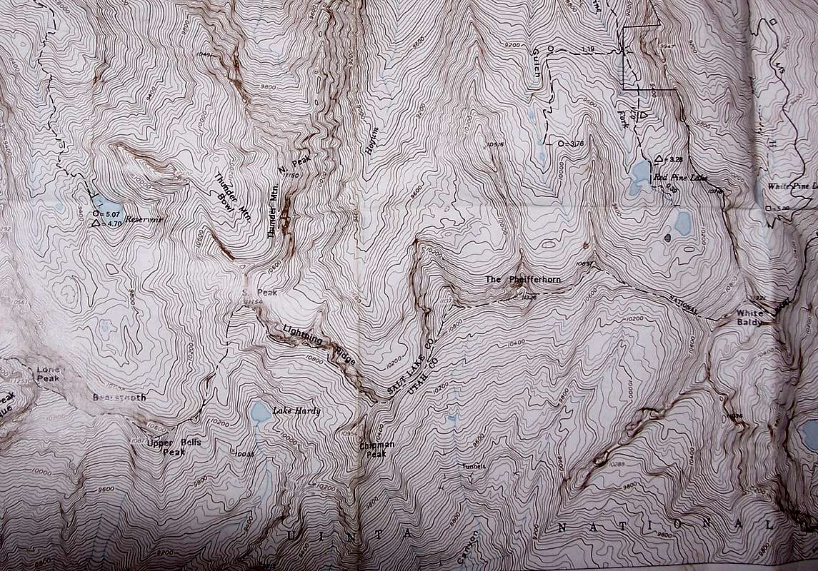
Thunder Mountain is actually Peaks 11,154 and 11,150 farther west. This is how all local maps and sources label it (I can provide a scan of other maps if anyone is interested in seeing them). This should be Thunder Mountain:

http://listsofjohn.com/PeakStats/Climbers.php?Id=18151

See also the SP pages:

http://www.summitpost.org/south-thunder-mountain/151964

http://www.summitpost.org/north-thunder-mountain/153420

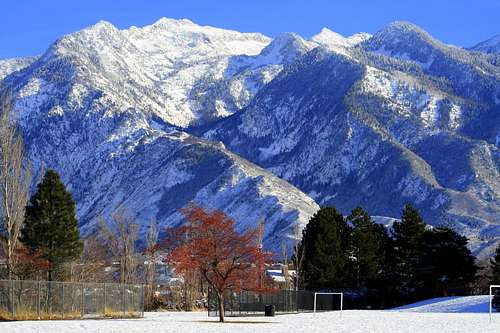
Thunder Mountain is the one visible from Salt Lake Valley, as seen here:

Image

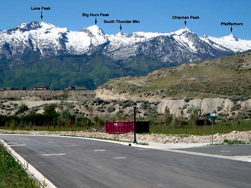
It can bee seen from the Utah Valley as well, but not as conspicuous:

Image

Google or Bing "Thunder Mountain Wasatch" for clarification (all will pull up 11,154 and 11,150):

http://www.bing.com/images/search?q=thu ... &form=QBIR

http://www.bing.com/search?q=thunder+mo ... ORM=HDRSC1

I think I can even find where the error came from. Thunder Mountain was not labeled on the old 7.5 minute map, but was on the old 1:250,000 scale map. Because the 1:250,000 scale map is at a small scale, the name "THUNDER MOUNTAIN" overlapped both peaks. It seems that someone down the line misinterpreted one of the old maps and the error just showed up (as in the last couple years) on the new USGS map. The error wasn't present until the brand new USGS maps just came out. I wonder how to get them to fix it?

Also, this peak is known as Big Horn or Upper Bells Peak depending on the local map used:

http://listsofjohn.com/PeakStats/Climbers.php?Id=18221

It may be good to include the name in the peak stats.
Scott Patterson
 
Posts: 146
Joined: Wed Aug 02, 2006 2:58 pm

Re: Thunder Mountain, Wasatch Range

Postby John Kirk » Sun Feb 17, 2013 12:08 pm

Looks like it was added in 1989 with this location:
Capture.JPG
User avatar
John Kirk
LoJ Architect
 
Posts: 1606
Joined: Sun Jan 02, 2005 1:04 am
Location: Lakewood, CO

Re: Thunder Mountain, Wasatch Range

Postby Scott Patterson » Tue Feb 19, 2013 7:23 pm

Looks like it was added in 1989 with this location:


Definitely an error and one that it easy to prove if the year it was added was 1989.

I have many maps and sources available both before and after 1989 that say the mountain facing the Salt Lake Valley is indeed Thunder Mountain.

Here is but one:

Image

I believe the 1989 error is probably due to the 1963 USGS Map for Salt Lake City:

Image

Notice that the name "Hogum Fork" is sort of in the way of where the print for Thunder Mountain (which is circled in red) should go. This is hardly unique to Thunder Mountain, but common to other mountains on the USGS map. Also circled is Mohogany Mountain. Just like Thunder Mountain, the name is to the right of Mohagany Mountain and no spot point designates which mountain is Mohagany (one could conclude by looking at the letters alone that the peak near the "Y" in Mohogany is Mohagany Mountain, which isn't the case. I'm guessing that this is what also happened with Thunder Mountain.

I have to go now, but I can provide many sources (maps, books, etc.), both before 1989 and after 1989 that show the correct location of Thunder Mountain.
Scott Patterson
 
Posts: 146
Joined: Wed Aug 02, 2006 2:58 pm

Re: Thunder Mountain, Wasatch Range

Postby John Kirk » Tue Feb 19, 2013 10:28 pm

User avatar
John Kirk
LoJ Architect
 
Posts: 1606
Joined: Sun Jan 02, 2005 1:04 am
Location: Lakewood, CO


Return to US Mountains

Who is online

Users browsing this forum: No registered users and 31 guests